Distribution of the Forests
The state has got natural sal forests in the district of West Champaran in the terai region of shivaliks. Besides, Sal forests are abundant in the southern Bihar in the districts of Kaimur, Rohatas, Aurangabad, Gaya, Jamui, Munger and Banka. The West Champaran district has moist deciduous Sal forest while south Bihar has dry deciduous Sal Forests. Most of the Natural Forests are notified as protected Forests. The Distribution of Forests in the Bihar State is as follows:
The state of Bihar presently has 7532.45 sq km notified natural forest area which is 8.00 % of the geographical area of the state. These natural forests are spread in the districts of West Champaran, Kaimur, Rohtas, Aurangabad, Gaya, Jahanabad, Nawada, Nalanda, Munger, Banka and Jamui.
The sub Himalayan foothill of Someshwar and Dun ranges in Champaran constitutes another belt of moist deciduous forests. This also consists of scrub, grass and reeds. Here the rainfall is above 1,600 mm and thus promotes luxuriant Sal forests in the favoured areas. The hot and dry summer gives the deduous forests. The most important trees are Shorea Robusta (Sal), Shisham, Cedrela Toona, Khair, and Semal.
Bihar Forests - At a Glance
| Sl. No. | Description | Area (in km²) | Age |
|---|
| 1. | Geographical Area | 94,163 | 100 |
| 2. | Forest Area | 7532.45 | 8.00 |
| 3. | Very Dense Forest | 387.00 | 0.41 |
| 4. | Moderately Dense Forest | 3284.21 | 3.49 |
| 5. | Open Forest | 3861.24 | 4.10 |
The Plant Species Composition
The important Tree species of Bihar are Sal (Shorea robusta), Shisham, Teak, Gamhar, Kadamb, Semal, Neem Peepal Bargad, Arjun, Asan, Haldu, Mahua and Kend etc.
Important wildlife species of Bihar

The State of Bihar is rich in wild animals. The important Terrestrial species are Tiger, Leopard, Bear, Hyena, Bison, Chital, Barking Deer etc. Besides there are many varieties of Crocodile, Magars and Fishes, Gangetic turtles in River systems.
Bihar has got the privilege of having the National Aquatic animal, Fresh water Dolphin in the River Ganges, Kosi, Gandak, Mahanada and Paimar rivers of the state etc. Vikramshila Gangetic Dolphin Sanctuary has been notified at Bhagalpur portion of the River Ganges. Bihar is also famous for different wetlands and many varieties of local bird species as well as migratory birds. Different Natural wetlands like Kanwar lake, Baraila lake, Kusheshwar nath Lake, Udaypur lake and man-made lakes Nagi Dam & Nakti Dam have been declared as Bird Sanctuary. The Bihar has breeding population of greater adjutants in Naugachia area of Bhagalpur district. The state has constructed a Rescue and Rehabilitation centre at Bhagalpur.
Protected Areas
| Sl. No. | Description | Number |
|---|
| 1. | National Parks | 1 |
| 2. | Tiger Reserve | 1 |
| 3. | Sanctuaries | 13 |
| 4. | Zoological Park | 2 |
| 5. | Conservation Reserve | 2 |
| 6. | Community Reserve | 1 |
| 11. | Total (Under Direct Management of the Forest Department) | 6472.9 km² |
| 12. | Ramsar Site | 6 |
Sanctuaries in Bihar
| Sl. No. | Name | District | Type |
|---|
| 1 | Barela Salim Ali-Zubba Sahni Wildlife Sanctuary | Vaishali | Wildlife Sanctuary |
| 2 | Bhimbandh Wildlife Sanctuary | Munger | Wildlife Sanctuary |
| 3 | Gautam Buddha Bird Sanctuary | Gaya | Wildlife Sanctuary |
| 4 | Kaimur Wildlife Sanctuary | Kaimur | Wildlife Sanctuary |
| 5 | Kanwar Lake Bird Sanctuary | Begusarai | Wildlife Sanctuary |
| 6 | Nagi Dam Bird Sanctuary | Jamui | Wildlife Sanctuary |
| 7 | Nakti Dam Bird Sanctuary | Jamui | Wildlife Sanctuary |
| 8 | Rajgir Wildlife Sanctuary | Rajgir | Wildlife Sanctuary |
| 9 | Sanjay Gandhi Biological Park | Patna | Zoo and Botanic Garden |
| 10 | Udaypur Vanya Prani Sanctuary | Champaran | Wildlife Sanctuary |
| 11 | Valmiki National Park | West Champaran | National Park |
| 12 | Valmiki Vanya Prani Sanctuary | West Champaran | Wildlife Sanctuary |
| 13 | Vikramshila Gangetic Dolphin Sanctuary | Bhagalpur | Wildlife Sanctuary |
Valmiki National Park
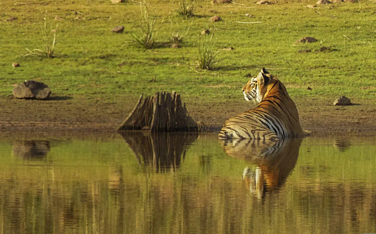
Valmiki National Park is a tiger reserve in the West Champaran District of Bihar. It is the only national park in Bihar. The Valmiki Tiger reserve, Bettiah has scripted the remarkable success in Tiger Conservation. In the year 1994 the conservation practice has started to protect Tiger under Project Tiger.
Department is continuously working for Fire Prevention and Management along with the Eco-Tourism activity. For Habitat development weed removal practice is regularly being done with the development and maintenance of grassland in all the blocks of the reserve. For wildlife management and Monitoring Radio Collaring of Tiger is being done for which proper training of field functionary is being done.
Notably, the tiger population has surged from 10 in 2006 to an impressive 54 in 2023 which is a roaring success for the reserve. Increase in the bison population in VTR, extensive grassland management, large-scale removal of invasive weeds and the fortification of the protection regime along the international border with Nepal through collaboration with SSB highlight VTR's commitment to ecological balance. Reintroduction of Rhino, the species which was naturally residing in VTR, is also in the final stage of implementation. The Himalayan vulture making Ganauli and Madanpur its habitat suggests ecological recovery and improved conservation management in Valmiki Tiger Reserve.
Awards and Citations
- Management Effectiveness Evaluation (MEE) – 2018
The National Tiger Conservation Authority (NTCA) rated Valmiki Tiger Reserve as “Very Good” under the Management Effectiveness Evaluation (MEE) – 2018. This recognition reflects the Reserve’s effective protection measures, habitat management practices, and adherence to national conservation standards.
- Tiger Population Assessment
As per the All India Tiger Estimation conducted by NTCA in 2018, the tiger population in Valmiki Tiger Reserve increased significantly from 8 to 31 individuals, demonstrating a positive population trend and the success of conservation interventions undertaken in the Reserve. 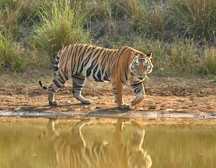
- RBS Earth Hero Award – 2017
Valmiki Tiger Reserve was conferred the prestigious RBS Earth Hero Award (Earth Guardian Category) in 2017 in recognition of its outstanding contribution toward wildlife conservation and sustainable environmental management.
- CATS Accreditation – 2021
Valmiki Tiger Reserve fulfilled all requirements under the Conservation Assured | Tiger Standards (CA|TS) and was officially recognized under the CATS (Conservation Assured Tiger Standard) framework in 2021. This international accreditation acknowledges the Reserve’s compliance with globally accepted standards for tiger conservation and protected area management.
- India Biodiversity Award – 2021
The Reserve received the India Biodiversity Award (2021) for excellence in the conservation of wild species, recognizing its commitment to biodiversity protection and ecosystem conservation.
- SKOCH Award Winner for Silver Category in Forest
The Reserve received the SKOCH Award -2024 for Effective habitat management.
Hariyali Mission & Jal-Jeevan-Hariyali Abhiyan
To promote the green cover of the state, the Department of Environment, Forest and Climate Change is promoting plantation in forest and non-forest areas, soil and water conservation work in forest areas, plantation under agro-forestry through farmers and ensuring availability of plants from departmental nurseries as well as private nurseries with the cooperation of the general public.
The Jal-Jeevan-Hariyali Abhiyan is a meaningful step taken by the government. Through this campaign, a meaningful effort is being made to connect the general public with environmental protection. An awareness program for the Jal-Jeevan-Hariyali Abhiyan was launched on August 9, 2019, on the occasion of Bihar Earth Day. The Jal-Jeevan-Hariyali Abhiyan was inaugurated by the then Honourable Chief Minister of Bihar Shri Nitish Kumar on October 2, 2019, on the occasion of the 150th birth anniversary of the Father of the Nation, Mahatma Gandhi.
To give concrete shape to this ambitious Jal-Jeevan-Hariyali Abhiyan of the Bihar government, the Department of Environment, Forest and Climate Change, Bihar, is working under two main components:
Component: 5 Construction of check dams and other water harvesting structures in small rivers/streams and water catchment areas of hilly areas.
Component: 8 Creation of nurseries and intensive tree plantation.
Status of green cover
In order to monitor the progress of the plantation schemes/campaign/programme to increase the green cover, the Department of Environment, Forest and Climate Change, Bihar has conducted a detailed mapping of the forest cover in and outside the Recorded Forest Area with high resolution LISS-IV, satellite imagery (instead of the commonly used LISS III satellite imagery) through the Forest Survey of India in two phases viz., in the year 2019 and 2024. The FSI has submitted its report for the phase II in the year 2024.
As per the said Report, 2024 from the FSI, the forest cover in and outside the Recorded Forest Area in Bihar is 12.55% of the total Geographical Area of the State. Whereas, as per the latest ISFR Report 2023 of the FSI (based on LISS III satellite image), the Tree Cover (Tree Outside Forest) in Bihar is 2.5%. Therefore, presently, in Bihar, putting together the Forest Cover and Tree Cover is 15.05% of the total Geographical Area of the State.
The report of Forest Survey of India based on LISS III and LISS IV satellite imagery shows that the forest and tree cover (Tree Outside Forest) been increasing steadily in the State of Bihar. The Department of Environment, Forest and Climate Change, Bihar has been continuing with the plantation drive guided by the targets of the States' policy enunciated in the 4th Krishi Road Map (Agriculture Road Map).
Rajgir Zoo Safari

State's first "Zoo Safari" has been constructed on an area of 191.12 hectares in Rajgir (Nalanda). It was inaugurated by the then Honourable Chief Minister of Bihar on February 16, 2022. Tourists can view wildlife and the biodiversity available in open areas while sitting in a vehicle. The concept of the zoo safari attempts to combine two completely different concepts: a zoo and a natural jungle safari, where wildlife can roam in a small natural habitat while tourists also enjoy a jungle safari. Rajgir Zoo Safari is being seen as a model zoo across the country
The safari zone has been developed for five species of wildlife: lion, tiger, leopard, bear, and herbivore species including chital, sambar, hog deer, barking deer, blackbuck etc. These include enclosure boundaries, double gates, retiring rooms, a safari road for tourist vehicles, drinking water facilities, and habitat enhancement.
Bihar's first aviary has been constructed at the Rajgir Zoo Safari, which was inaugurated by the then Honourable Chief Minister of Bihar on March 8, 2025. An aviary is a special structured area where a variety of exotic birds live safely and freely. It provides an ideal environment for these birds, resembling their natural habitat.
Sanjay Gandhi Biological Park, Patna
Sanjay Gandhi Biological Park, Patna (Patna Zoo) is one of the largest zoos in India, and the only zoo in the state of Bihar. In the 2022 World Economic Forum, Sanjay Gandhi Biological Park, Patna has been selected among the top 10 best zoos in the country, securing fourth place in the category of largest zoos in the country and sixth place in the overall category.
Eco-Tourism and Park Development
The government plans to develop eco-tourism areas and sites in the state and enhance public amenities. The state is blessed with numerous naturally beautiful and picturesque sites, and the field of eco-tourism holds immense potential. Parks are being expanded, developed, and maintained in all districts of the state to maintain environmental balance and prevent pollution.
Ramsar Sites
In terms of the number of Ramsar Sites, Bihar ranks third in the country. Currently, six wetlands in the state of Bihar, namely – Kanwar tal Wetland, Begusarai (Year 2020), Nagi Bird Sanctuary, Jamui (Year 2024), Nakti Bird Sanctuary, Jamui (Year 2024), Udaypur Jheel, Bettiah (Year 2025), Gogabeel, Purnia (Year 2025), and Gokul Jalashay, Bhojpur (Year 2025), have been declared as Ramsar Sites.